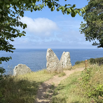
Opalsøen – turquoise quarry lake on the Hammeren peninsula

Opalsøen (Danish for "opal lake") is one of the most striking sights on northern Bornholm — a deep, turquoise lake in a former granite quarry on the Hammerknuden peninsula. Steep rock walls plunge into crystal-clear water, and from the quarry rim you get a panorama of the Baltic Sea and surrounding forests. An ideal spot for a short walk, a scenic stop on a hike, or — in summer — a swim in one of Denmark's deepest natural "pools".
The granite history of Hammerknuden
Opalsøen is the legacy of northern Bornholm's largest granite quarry. From the late 19th century until about 1970, granite was extracted here under Danish and German ownership — the stone was shipped from nearby Hammerhavn harbour (also called Sæne Havn). After the quarry closed, the pit slowly filled with water, creating today's deep lake. The sheer walls and turquoise surface give the landscape an almost surreal character — especially on sunny days, when the water shifts from emerald to blue.
 Goats on Hammerknuden near the trail to Opalsøen
 Hiking trail around Opalsøen lake on Hammerknuden
Swimming, trails and Denmark's longest zip line
Opalsøen is an official bathing spot — but note: the lake is very deep and you cannot stand anywhere. Swimming is only for those who can swim. In summer Denmark's longest zip line (tovbane) operates by the lake — a particularly popular attraction for families with children.
Several hiking trails of varying length run around the quarry. The shortest leads from the car park at Hammer Sø (about 15 min); longer routes connect Opalsøen with Hammeren Fyr lighthouse, Krystalsøen and Hammerhavn harbour. From the cliff top you can see the Baltic on both sides of the peninsula and the ruins of Hammershus castle in the distance.
Hammerhavn harbour – café and starting point
Views, goats and a rocky landscape
Hammerknuden is more than Opalsøen — the entire peninsula is densely covered with low trees and criss-crossed by granite walls. On the open clearings you may encounter goats grazing freely and approaching tourists with curiosity. From viewpoints above the quarry you can also see neighbouring Krystalsøen (smaller but equally charming) and a panorama of Sandvig and the sea.
- Turquoise lake in a former granite quarry — deep, bathing allowed (swimmers only)
- Denmark's longest zip line (tovbane) — open in summer
- Several hiking trails (from 15 min to 2 hours) — from Hammer Sø car park or Hammerhavn
- Panoramic views of the Baltic from both sides of the peninsula
- Goats grazing freely on Hammerknuden
- Nearby: Hammeren Fyr lighthouse, Krystalsøen, Hammershus ruins
Former quarry — today a nature area
The granite story of Hammerknuden dates back to the second half of the 19th century — extraction supplied raw material across Denmark. After the quarry closed in 1970, nature gradually reclaimed the site: steep walls became moss-covered and the pit floor filled with clear water. Today Opalsøen is part of a protected nature area and one of the most photographed places on the island.
 View of Opalsøen from the rim of the former granite quarry
Good to know about Opalsøen
- Former granite quarry — active from the late 19th century until about 1970
- Deep bathing lake (swimmers only — no standing depth)
- Denmark's longest zip line — open in summer
- Free access; several hiking trails of varying length
- Location: Hammersøvej/Sænevej, 3770 Allinge — near Hammer Sø and Hammerhavn
- Nearby: Hammeren Fyr lighthouse, Krystalsøen, Hammershus ruins
Lokalizacja
| Opalsøen | |
| Hammersøvej/Sænevej, 3770 Allinge | |
| Lake on the Hammerknuden peninsula in northern Bornholm. Walking access from Hammer Sø car park (approx. 15 min) or from Hammerhavn harbour. | |
| Free car park at Hammer Sø lake (Hammersøvej). Alternatively parking at Hammerhavn harbour. |